Data Model
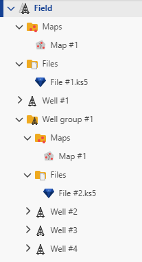
The Data Model is a hierarchy with a Field at the top level. A Field contains Wells .
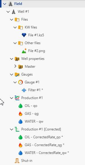
Wells have two different types of data, which are Gauges and Well properties.
Gauges are data time series of different types. If they are high frequency, the gauges can be/should be decimated with possible denoising for further processing; the filtered data are gathered under the gauge from which they are obtained.
Well properties, aka well static properties, also can cover multiple types and they are also potentially time series. The well properties can be used to define static properties or to hold analyses results. The sets of properties are kept in properties containers under Well properties folder.
Wells are created with a special Production container object which can hold the phase rates (Oil, Gas, Water). Corrected Production can be created to synchronize the rates with the pressure and make other rates corrections if needed.
Pressure-rates synchronization is necessary to perform pressure/rate transient analysis and requires a special shut-in channel to be created. Sometimes automatically created shut-in channel needs validation; both the raw shut-in and the validated shut-in are placed in the Shut-in folder.
Different Files can be associated with the well level and organized in folders with possible nesting.
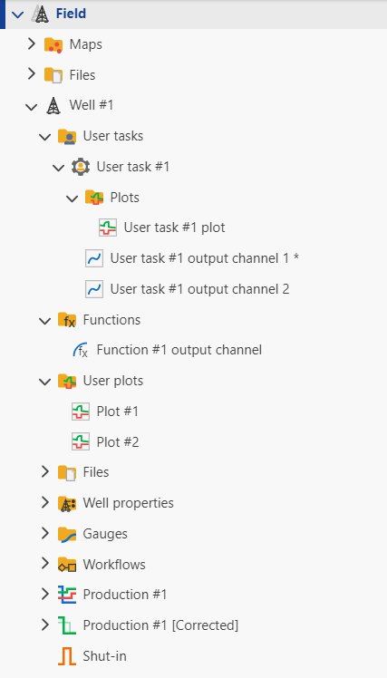
If built-in workflows are created, the results are placed in the dedicated Workflows folder.
User can create new data sets. The new channels, if they are simple functions of the loaded data, are placed in the Functions folder. The data created with the help of user tasks can be placed either under the Gauges or under the User Tasks folder.
User can create simple plots from data series; they are gathered in the User Plots folder. The plots created with the help of user tasks, that are often more sophisticated than user plots, can be put either under the User Tasks in the Plots folder or in Plots folder under the Well.
The wells can be organized in Well Groups. It is also possible to associate Files with the Well Group level or even with the Field level.
You can create Maps for all the Wells in the Field or for Wells in a Well Group.